Helsinki logo History Helsinki
Select site language
Suomi Svenska English
Close Menu
Navigation menu
  • Phenomena
    Phenomena Toggle submenu: Phenomena
    • Events throughout the year
    • Constantly changing everyday life
    • Heading out to sea and into the wide world
  • Regions
    Regions Toggle submenu: Regions
    • Southern
  • Turning points
    Turning points Toggle submenu: Turning points
    • Origins and 16th century
    • 18th century
    • 19th century
    • 20th century
  • History on maps
Main navigation
  • Phenomena
    • Events throughout the year
    • Constantly changing everyday life
    • Heading out to sea and into the wide world
  • Regions
    • Southern
  • Turning points
    • Origins and 16th century
    • 18th century
    • 19th century
    • 20th century
  • History on maps

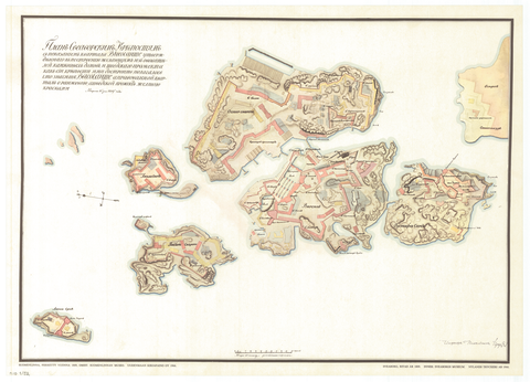
Map of Suomenlinna 1809

Map of Suomenlinna 1809
« Back to search results
« Back
Share icon Share
Share in Facebook Share in Linkedin Share in Twitter Send as an email
Venäjänkielinen Suomenlinnan kartta vuodelta 1809.
A map of Suomenlinna in Russian from 1809.
Location marker icon Show on map

Used in articles

The Imperial Finnish Senate in a 1838 lithograph. Most likely based on an 1827 watercolour by C. R. Westling.

1812 – Capital City

Article Article
Go to content

Photographer

Helsinki City Archives

Phenomena

Vallankäyttöä ja hallintoa

Period

1809

Formats

Map

Keywords

Suomenlinna maps

Copyrights

CC BY 4.0

Buildings

Helsinigin kaupunginarkisto
Helsinki logo
  • Give feedback(Link leads to external service)
  • Accessibility
  • Cookie settings
Back to top