Helsinki logoHistory Helsinki
Select site language
Suomi Svenska English Русский
Close Close navigation menu Menu Open navigation menu
Navigation menu
  • Phenomena
    Phenomena Toggle submenu: Phenomena
    • Events throughout the year
    • Constantly changing everyday life
    • Heading out to sea and into the wide world
  • Regions
    Regions Toggle submenu: Regions
    • Southern
  • Turning points
    Turning points Toggle submenu: Turning points
    • Origins and 16th century
    • 18th century
    • 19th century
    • 20th century
  • History on maps
Main navigation
  • Phenomena
    • Events throughout the year
    • Constantly changing everyday life
    • Heading out to sea and into the wide world
  • Regions
    • Southern
  • Turning points
    • Origins and 16th century
    • 18th century
    • 19th century
    • 20th century
  • History on maps

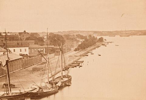
Pohjoissatama (= North Harbour) 1872

Pohjoissatama (= North Harbour) 1872
« Back to search results
« Back
Share icon Share
Share in Facebook Share in Linkedin Share in Twitter Send as an email
The southern end of Pohjoinen rantakatu, now Pohjoisranta, with small boats and larger vessels at the North Harbour. The current stone houses along the street were built from the 1870s onwards, and the current T-shaped Halkolaituri pier in 1889–1891.
Location marker icon Show on map

Used in articles

An aerial view of Kruununhaka and the Siltavuorensalmi strait. The Hakaniemi bridge is in the middle of the image.

Kruununhaka – a city district of social strata

Article Article
Go to content

Photographer

Helsinki City Museum / Eugen Hoffers

Finna.fi record

(The link opens in a new tab.) Open in new window(Link leads to external service)

Formats

Image Photo

Authors

Hoffers, Eugen

Copyrights

CC BY 4.0

Buildings

Helsinki City Museum
Helsinki logo
  • Give feedback(Link leads to external service)
  • Accessibility
Back to top