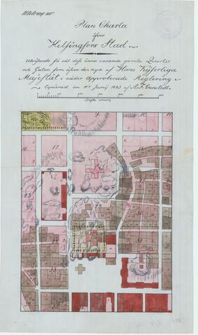
A map of the Kruununhaka district from 1820. The new wider streets and city blocks designed in the new grid plan are drawn in pink on top of the former streets and blocks. The finished areas of the new city plan are marked in dark red. Three church buildings are marked on the map with a cross: Ulrika Eleonora's church on the Senate Square, The Church of St. Nicholas north of the square, and further north a large Orthodox church that was ultimately not built. Instead, a smaller Orthodox church –– the Holy Trinity Church –– was built on the northside of St. Nicholas’s Church, facing the University Library.
A. F. Granstedt: Plan Charta Över Helsingfors Stad Utvisande Så Väl Dess Ännu Varande Gamla Qvarter Och Gator.